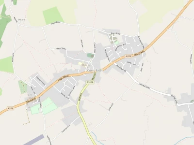
It can hardly have escaped anybody's notice that the long line of Leylandiae conifers abutting the A378 west of Parsonage Place that had been growing there for about thirteen years have been felled, stripped of their foliage and removed with only two or three feet of their trunks remaining above ground.
These stumps will be pulled or grubbed out in the near future.
What is the rationale for this destruction of vibrant growing trees so quickly consuming CO2 contrary to the current green agenda?. An explanation is very necessary, and the following narrative provides a detailed explanation for the apparent 'vandalism'.
The large field now exposed by the removal of the trees is a sloping grass covered field that was the delightful green centre of the village. Prior to the planting of the trees it was previously mown, but now with the trees gone it can be seen to have reverted to natural uncontrolled growth.
On the 6 th of March 2017, an Outline Planning Application was made to South Somerset District Council (SSDC) Planning Department for permission to build 8 dwellings with attached garages in the northern area of the field, and connect this development to the A378, the main road through the village, with a residential road emerging at a right angles onto that highway.
Because this was a development essentially on open countryside, (which was not allowed except in exceptional circumstances under the Local Development Plan and also because of the dangers presented by the siting of the entry road onto the hugely heavily used A378), the South Somerset District Council (SSDC) would not consider this application until the Applicant agreed to the imposition of a special mitigation clause called a S106. The S106 is designed to recompense the SSDC and the local inhabitants with either monetary contributions or other ways of mitigating the resultant loss of space, congestion of roads or loss of visual amenity resulting from a new development.
The site in question lies behind the long ancient crumbling blue lias stone wall which contains an earth level which is about a metre higher than the level of the narrow pavement in front of it, which runs alongside the A378 for it's entire length. SSDC were very concerned about the junction of the estate road with the A378, because the traffic travelling along that road in either direction could not be adequately seen by anyone in a vehicle emerging from that junction.
Therefore, it was necessary that the Highways Department in the County Council impose a requirement that this wall should be moved back and splayed in both directions so that all vehicles leaving the site could be clearly seen by all vehicles transiting the A378, and at the same time no leaving vehicle needed to be physically on the A378 in order to see that it was clear and safe to join that road. This required considerable time to negotiate with the Applicant, because the Planning Department in SSDC had major staffing deficiencies, as did the County Council. In addition the S106 required that the frontal southern end of the field should not in the future be subject to any development in order to preserve the previous visual aspect of the site as far as possible, and that if approved the new housing complex should be partially hidden from the road by a stone or brick wall with only an opening in it for the estate road access, thus dividing it from the southern undeveloped section of the historic field.
It was suggested by the Applicant that, in compliance with the S106, the southern portion of the land should be gifted to the Parish Council(PC) once the last dwelling was nearing completion. To this end the Applicant and his Agent attended the PC on several occasions in 2018 to make this offer, and under a previous Chairman, an agreement in principle for acceptance was voted for by the Council.
It has to be said that there were some matters of concern about the ultimate full acceptance of the offer, which rested on a legal agreement to be reached in the future covering the responsibilities of both the Applicant and the PC in respect to both the conditions and facilities allowable and provided on and surrounding the potentially gifted land. These included a 1.5 metre transverse path across the site, the addition of two pedestrian entrances to the site, one sloping and the other with steps that had already been triggered by the S106.
Following this there was a long hiatus due to the absence of adequate planners, the pandemic and lockdowns, diversions of council staff to other duties, working from home along with self isolation, which virtually stopped any progress until very recently, when the undertakings for the gifted land, (i..e. what the Parish Council would be obligated to maintain, undertake, and what structures would be provided and maintained by the Applicant) were fully discussed at a working group meeting with the Applicant held on the 7th July this year.
Following these detailed discussions of what are known as Heads of Terms (HOTs), a clearer way forward emerged, culminating in a full Parish Council question and answer session with the Applicant on the 5th of August this year where a final decision by a named vote was required. The named vote resulted in 4 votes for acceptance and 4 votes for rejection of the land gift, and I had to use my casting vote in favour of acceptance. Therefore, the PC will now own the land, if and when, the Outline planning permission is granted and the various contentious points in the HOTs, which are now nearly fully mutually agreed, are made legally binding on both sides.
The removal of the trees was a sad necessity but a necessary first step in a very long and complex process. Therefore now it is a case of "watching this space"
Derek Yeomans
Chairman of Parish Council
Get In Touch
CurryRivelOnline is powered by our active community.
Please send us your news and views.
Email: editor@curryrivel.org.uk
